About The Old Pecos Trail Scenic Corridor

The Old Pecos Trail Scenic Corridor (OPTSC)
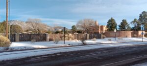
The OPTSC is a narrow strip of land on either side of the street called Old Pecos Trail. The corridor starts at Exit 284 of Interstate 25 in the south, and heads northwest approximately 2.5 miles up to where Cordova and Armenta Roads intersect with Old Pecos Trail. This strip has been identified as worthy of preservation, as an important gateway directly into the historic district, and directly into the very heart of our Capital City.
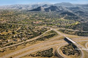
(aerial view from I-25 looking north)
The OPTSC was defined by the City of Santa Fe General Plan 1999:
Chapter 3, Land Use Corridor Protection Areas, page 3-12:
“The Old Pecos Trail Scenic Corridor designates Old Pecos Trail, between Cordova Road and 1-25, as a scenic roadway and recognizes its importance as an unspoiled entryway into downtown. Development standards, including land uses, density, and design controls, will be developed through a public participation process.”
and, in the chapter Implementing Policies, page 3-14:
“Adopt an Old Pecos Trail “Scenic Corridor” designation and development standards for the Old Pecos Trail between Cordova Road and I-25”

from: General Plan of the City of Santa Fe, NM, 1999
OPTSC is marked as dotted lines from I-25 to Cordova/Armenta Roads. See full Plan here:
For more information, email us at: friendsofopt@gmail.com